NASA image of Chandrayan-2 landing site fails to locate Vikram lander
27 Sep 2019
1
NASA’s Lunar Reconnaissance Orbiter Camera (LROC) captured the site the targeted landing site image of Chandrayaan-2 lander, Vikram, in a Quickmap fly-around of the area, which is about 150 kilometers across the centre.
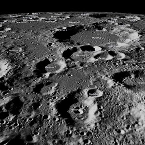
The Lunar Reconnaissance Orbiter (LRO) passed over Vikram’s landing site on 17 September and acquired a set of high resolution images of the area. However, the LROC team has not been able to locate or image the lander.
“It was dusk when the landing area was imaged and thus large shadows covered much of the terrain; it is possible that the Vikram lander is hiding in a shadow,” NASA pointed out.
The Chandrayaan-2 lander, Vikram, attempted a landing, on 7 September, on a small patch of lunar highland smooth plains between Simpelius N and Manzinus C craters. Vikram had a hard landing and the precise location of the spacecraft in the lunar highlands has yet to be determined, NASA said in its latest update.
The lander, Vikram, was scheduled to touchdown on 7 September (6 September 4:24 pm Eastern Daylight Time in the US). This event was India's first attempt at a soft landing on the Moon. The site was located about 600 kilometers (370 miles) from the south pole in a relatively ancient terrain (70.8°S latitude, 23.5°E longitude).
The Lunar Reconnaissance Orbiter (LRO) passed over the landing site on 17 September and acquired a set of high resolution images of the area; so far the LROC team has not been able to locate or image the lander. It was dusk when the landing area was imaged and thus large shadows covered much of the terrain; it is possible that the Vikram lander is hiding in a shadow.
NASA hopes to get a clearer image in a more favourable lighting when LRO passes over the site in October and once again attempts to locate and image the lander.
This was a reconfirmation of Indian Space Research Organisation’s announcements about losing all contacts with the Viram lander after its failed attempt at soft landing.
The remaining orbiting module of the Chandrayan-2 mission has a camera with a 30-cm resolution. Isro already has pictures sent by it from its 100-km height soon after the landing failed.
The landing region lies between two craters about 70° south of the lunar equator and about 600 km from its shadowy south pole.
The orbiting Chandrayaan-2 and the LRO routinely fly over the same spot at regular intervals. Images from their next flyovers could help ISRO give conclusive information, Indian experts said earlier.
The LRO, orbiting moon since September 2009, has a camera with 50-cm high resolution and goes around in an eccentric orbit of 20 km x 165 km.