India set to launch IRNSS-1B satellite on 4 April
02 Apr 2014
1
The Indian Space Research Organisation (ISRO) said today that it has completed the integration of its indigenously made regional navigation satellite IRNSS-1B with the satellite's launch vehicle PSLV-C24.
 The lift-off is slated for 4 April at 5.45 pm from the ISRO spaceport at Sriharikota in Andhra Pradesh.
According to ISRO officials, the spacecraft has been integrated with the launch vehicle and global checks are in progress.
IRNSS-1B is India's second regional navigation satellite system. This will be the 26th flight of Polar Satellite Launch V, including Chadrayaan-1, GSAT-12, and Mangalyaan or Mars Orbiter Spacecraft mission.
This indigenous satellite will reduce India's dependence on GPS used by the United States and the Russian GLONASS.
It will provide Standard Positioning Service (SPS) to all users and Restricted Service to authorised users. The satellite is designed to provide accurate position information service to users in India and in the region extending up to 1,500 km, according to an ISRO statement.
According to an Indian Science Journal (ISJ) report, the satellite's application will be in the areas of terrestrial, aerial and marine navigation, disaster management, vehicle tracking and fleet management, integration with mobile phones, mapping and data capture, terrestrial navigation aid for hikers and travellers, and visual and voice navigation for drivers.
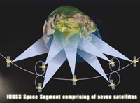
IRNSS comprises a space segment and a ground segment - seven satellites, three in geostationary orbit and four in inclined geosynchronous orbit, in the space segment. The ground segment handles navigation parameter generation and transmission, satellite control, ranging and integrity monitoring and time keeping.
The spacecraft with a lift-off mass of 1432 kgs, will have a mission life of 10 years. It will be powered by two solar panels and a Lithium-ion battery and the propulsion system consists of a Liquid Apogee Motor and thrusters.
The satellite will be launched into a sub Geosynchronous Transfer Orbit (sub GTO) with a 284 km perigee (nearest point to Earth) and 20,652 kms of apogee (farthest point from Earth) with an inclination of 19.2 degree to equatorial plane.
The lift-off is slated for 4 April at 5.45 pm from the ISRO spaceport at Sriharikota in Andhra Pradesh.According to ISRO officials, the spacecraft has been integrated with the launch vehicle and global checks are in progress.
IRNSS-1B is India's second regional navigation satellite system. This will be the 26th flight of Polar Satellite Launch V, including Chadrayaan-1, GSAT-12, and Mangalyaan or Mars Orbiter Spacecraft mission.
This indigenous satellite will reduce India's dependence on GPS used by the United States and the Russian GLONASS.
It will provide Standard Positioning Service (SPS) to all users and Restricted Service to authorised users. The satellite is designed to provide accurate position information service to users in India and in the region extending up to 1,500 km, according to an ISRO statement.
According to an Indian Science Journal (ISJ) report, the satellite's application will be in the areas of terrestrial, aerial and marine navigation, disaster management, vehicle tracking and fleet management, integration with mobile phones, mapping and data capture, terrestrial navigation aid for hikers and travellers, and visual and voice navigation for drivers.
IRNSS comprises a space segment and a ground segment - seven satellites, three in geostationary orbit and four in inclined geosynchronous orbit, in the space segment. The ground segment handles navigation parameter generation and transmission, satellite control, ranging and integrity monitoring and time keeping.
The spacecraft with a lift-off mass of 1432 kgs, will have a mission life of 10 years. It will be powered by two solar panels and a Lithium-ion battery and the propulsion system consists of a Liquid Apogee Motor and thrusters.
The satellite will be launched into a sub Geosynchronous Transfer Orbit (sub GTO) with a 284 km perigee (nearest point to Earth) and 20,652 kms of apogee (farthest point from Earth) with an inclination of 19.2 degree to equatorial plane.