ISRO launches IRNSS-1G to complete satellite navigation system
28 Apr 2016
Indian Space Research Organisation (ISRO) today successfully placed IRNSS-1G, the last in the series of seven navigational satellites that will now give India its own satellite navigational system similar to the GPS system of the United States.
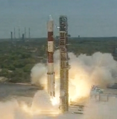 A four-stage Polar Satellite Launch Vehicle (PSLV-C33) took off from the launch pad at the Satish Dhawan Space Centre in Andhra Pradesh's Sriharikota island today exactly at 12.50 am and placed the IRNSS-1G satellite in a sub-geosynchronous transfer orbit (Sub-GTO) as planned.
IRNSS-1G is the seventh navigation satellite of the seven satellites constituting the IRNSS space segment. Its predecessors - IRNSS-1A, 1B, 1C, 1D, 1E and 1F - were launched by PSLV-C22, PSLV-C24, PSLV-C26, PSLV-C27, PSLV-C31 and PSLV-C32 in July 2013, April 2014, October 2014, March 2015, January 2016 and March 2016 respectively.
Like all other IRNSS satellites, IRNSS-1G also has a lift-off mass of 1,425 kg. The configuration of IRNSS-1G too is the same as IRNSS-1A, 1B, 1C, 1D, 1E and 1F, Isro stated in a release.
IRNSS-1G also carries two types of payloads – navigation payload and ranging payload. The navigation payload of IRNSS-1G will transmit navigation service signals to the users. This payload will be operating in L5-band and S-band.
A highly accurate Rubidium atomic clock is part of the navigation payload of the satellite. The ranging payload of IRNSS-1G consists of a C-band transponder, which facilitates accurate determination of the range of the satellite.
The satellite with a design life span of 12 years has two payloads for navigation and ranging.
IRNSS satellites once placed in their respective slots, will provide two types of services, viz., Standard Positioning Service (SPS) to all the users and Restricted Service (RS), an encrypted service provided only to authorised users.
IRNSS system is expected to provide a position accuracy of better than 20 metre in the primary service area.
Isro will locate three of the IRNSS satellites in suitable orbital slots in the geostationary orbit and the remaining four in geosynchronous orbits with the required inclination and equatorial crossings in two different planes.
All the satellites of the constellation are configured identically.
Though the full system comprises nine satellites - 7 in orbit and 2 on the ground as stand-by - ISRO is yet to take a decision on stand-by options.
India, which has proved to the world its robust and cost-effective indigenous technologies with the success of Mangalyaan (Mars Mission), has now realised the country's long cherished dream of owning an indigenous satellite navigation system.
IRNSS will be operational with just 7 satellites while China's regional system 'Beidou' is a constellation of 35 satellites!
It took almost 17 years for Indian space scientists to complete the indigenous satellite navigation system after the US in 1999 refused to share GPS data with India that would have provided vital information on Pakistani troop positions during Kargil war.


.webp)