European Space Agency’s Biomass to “weigh” the earths’ forests
08 May 2013
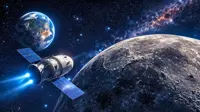
A satellite that can "weigh" the earth's forests has just received the go ahead from the European Space Agency.
The launch of Biomass, as it would be known is expected to happen in 2020.
 |
| Image © European Space Agency |
The spacecraft would carry a novel radar system able to sense the trunks and big branches of trees from orbit.
Biomass would be used by scientists to calculate the amount of carbon stored in the world's forests, and for monitoring any changes over the five-year mission.
With the help of the data from the satellite, researchers would be better able to under the role played by trees in cycling of carbon on earth and how this the influences the the planet's climate.
According to Prof Shaun Quegan, of the University of Sheffield, who was one of the key proposers of the mission, and one of the key investigators now supporting it, Biomass would give scientists an unprecedented knowledge on the state of the world's forests and how they were changing.
The satellite would be the seventh of the agency's so-called Earth Explorers - a series of spacecraft designed to conduct innovative science for obtaining data on issues of pressing environmental concern.
Three missions thus far sent into orbit that have provided remarkable new information on gravity, polar ice cover, soil moisture and ocean salinity.
Biomass would produce the first accurate maps of tropical, temperate and boreal forest biomass from space, which would help scientists address fundamental questions about changes in biodiversity, especially in tropical regions, where ground data is scant. They would also help quantify the carbon emissions resulting from deforestation and land-use change.
Quegan said, understanding how the amount of living material - biomass - in our global forests changed over time was necessary for improving present and future assessments of the earth's climate.
Currently, estimates of biomass used in climate models are obtained from ground-based measurements, but given the measurements were scarce, the models gave radically different projections of future climate.
The Biomass mission would help overcome that problem, by providing a database of accurate, calibrated biomass measurements, aligning current climate models with each other. It would also do this with the help of a 70-centimetre-wavelength radar sensor to probe both the height of trees, and the size of their trunks and canopies, in minute detail.
Apart from providing an unparalleled insight into forest biomass, the mission could also provide information on ice-sheet thickness, permafrost levels, soil moisture and subsurface geology in arid regions.
The concept for Biomass had become possible only over the last five years following the international telecommunications union allotting a wavelength frequency to remote sensing.